How IT Consulting Companies Can Sell Mapify
May 22, 2024
Ana Guerra

In IT consulting, the tools and technologies you adopt can significantly influence the quality and efficiency of your services. If your projects involve any form of location-based component, be it mapping, proximity analysis, IoT sensoring, delivery tracking, or other geospatial data analysis, then Mapify emerges as a highly suitable tool for your needs. In this article, we explore why Mapify is an excellent fit for consultancy projects and how you can effectively sell it to your clients.
Enhancing project value for clients with location intelligence
In today’s data-driven world, geospatial information is key to unlocking insights and optimizing solutions. Mapify allows you to integrate sophisticated location data capabilities into your projects. Whether it’s for market analysis, logistics optimization, urban planning, or environmental assessment, Mapify is able to elevate your consulting services by adding a layer of location intelligence.
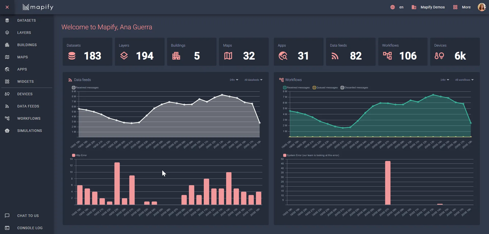
Here are some of the things you can easily do with Mapify:
- Mapify Maps: Using your browser, upload or connect to your data, style and share your interactive and beautiful maps.
- Mapify Apps: Create an app with the click of a button, customize the look and feel to your heart’s desire and the tools you want to include.
- Mapify Workflows: Automate tasks and messages, whether its updating data, sending an email or generating an incident.
- Mapify Simulations: Plan and simulate entire systems on your desktop or mobile before you even buy the device.
- Mapify Devices: Manage your devices and get real-time insights into their status and location.
Mapify makes developerment a lot faster too.

Subscription and integration flexibility
Mapify offers subscription models that can be integrated seamlessly into your IT consulting projects. You can use Mapify as a tool within your existing project framework, enhancing your deliverables with its advanced features. This flexibility allows for a more tailored approach to each client’s unique needs.
Key Benefits for your IT consulting company:
- Tailored Solutions: Adapt Mapify to meet specific project requirements.
- Scalability: Start small and scale up as the project demands increase.
- Cost-Efficiency: Choose subscription plans that align with your project's budget.
Reselling and support Services
Another avenue is to become a reseller of Mapify to your clients. This approach not only adds value to your consulting offerings, but also opens up a revenue stream for ongoing professional services. By supporting your clients with Mapify’s implementation and ongoing usage, you position your IT consulting company as a comprehensive solution provider.
How to resell Mapify:
- Demonstrate Value: Show potential clients how Mapify can solve their specific problems cheaper and faster.
- Offer Training: Provide training sessions to help clients understand and maximize Mapify’s features.
- Continuous Support: Offer ongoing support services to ensure clients can leverage Mapify effectively.
Customizable solutions for diverse industries
Whether your IT consulting company focuses on a specific sector or serves a broad range of industries, with Mapify, you have the freedom to customize according to your unique workflows, processes, and industry standards.
Take a look at these Mapify blog posts featuring popular use cases:
Create a simple web application to display Waze traffic alerts without any code
Waze, a popular traffic and navigation app, offers cities and their partners real-time updates on road conditions through its Waze for Cities program. Mapify can utilize Waze alerts to create a no-code web application that displays these updates on a Google Maps interface. By setting up a dataset, data feed, workflow, and real-time layer in Mapify, you can quickly build a traffic alert system without writing any code. This integration enhances city planning and infrastructure decisions, providing valuable insights for your IT consulting projects.
.webp)
Real-time vehicle and cargo tracking using Mapify
Mapify enhances logistics and supply chain management with real-time vehicle and cargo tracking using IoT sensors and no-code workflows. It provides instant insights into vehicle locations and status, including data on speed, temperature, and weight distribution, displayed on a Google Maps interface. Mapify's alert system offers real-time notifications for sensor changes, enabling swift responses to potential issues. Additionally, it simplifies parking management by tracking spot availability with color-coded indicators. Explore these features to boost efficiency and prevent costly disruptions in logistics operations.

Mapify has a lot to offer to smart cities
Mapify is an essential tool for developing smart city solutions, especially amid challenges like COVID-19 and global conflicts. It allows cities to handle vast amounts of real-time IoT data effortlessly. With Mapify, you can build IoT solutions quickly using a no-code approach, enabling features like real-time monitoring of road incidents, dynamic building categorization, and smart mobility solutions. Whether it's integrating public transportation data or setting up alerts for road conditions, Mapify provides the scalability and processing power needed for modern smart city infrastructure.

Automating agriculture workflows with Mapify
Mapify excels in automating agricultural workflows by combining location intelligence with no-code drag-and-drop workflows. It enables quick implementation of business rules without coding or managing infrastructure. For example, Mapify helped a large food processing company track and manage truck-based tomato containers from fields to processing plants. By geo-referencing fields and plants, creating real-time data feeds, and setting up workflows, the company optimized operations, increased efficiency by 20%, and reduced waste by 10%. This powerful tool can automate various tasks, making it ideal for modern agricultural needs.

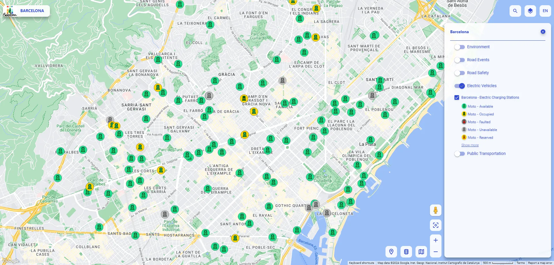
Build your environment and sustainability web app in one day
Mapify empowers you to quickly create impactful environmental and sustainability web apps. Using no-code drag-and-drop workflows, you can build applications like real-time Air Quality Index (AQI) monitors and electric vehicle charging station locators. With Mapify, you can integrate data from various sensors, set up alerts, and display information on interactive maps, all within a day. This platform allows you to develop scalable, environment-aware solutions rapidly, addressing urgent issues like pollution and energy consumption without needing to write any code.
Does it seem too good to be true? We have a couple of tutorials on YouTube explaining step-by-step how many of Mapify's features work.
However, we'd recommend starting with this one 👇
By adopting and promoting Mapify, you can not only enhance your service offerings, but also create new revenue streams and strengthen client relationships. Would you like to know more about how we can work together? Book a call right now.

.jpg)
.jpg)
.webp)