
Top 5 Open Data Repositories from Cities
October 12, 2023
Mário Sobral

British mathematician Clive Humby declared in 2006 that “data is the new oil,” underlining that data, like oil, isn't useful in its raw state. It needs to be refined, processed and turned into something useful; its true value lies in its potential to generate actionable information and help in decision-making.
Cities produce and are able to collect vasts amounts of data and most of it has a location component. From public transportation and traffic measurement to environment and air quality, from housing to garbage disposal, there is plenty of information that can be used to build solutions to improve people lives in cities.
This article highlights 5 interesting open data repositories provided or associated with several cities, which can be used by you to create new and innovative solutions. Mapify can help you build those solutions much faster and provides you with an easy to use and potentially no-code approach to rendering your data over a map.
Even though many cities share static data with some sort of geographic information, we value those which provide API access to the data, allowing you to build dynamic and interactive solutions which provide up-to-date information. One specific city goes one step further and even provides subscription access to its own MQTT broker, providing access to real time data as soon as it is published. Keep reading to find out what city's open data amazes you the most.
New York City
Country: USA
Open Data Portal: https://opendata.cityofnewyork.us/

New York City needs no introduction as one of the most iconic cities in the world. This city is known for "never sleeping", but its open data policies and shared data are also second to none.
Some of the publicly available datasets in the the official open data portal include building footprints, subway lines and stations, and much, much more. And even though it provides access to over 3500 datasets, there is still additional open data shared through additional city providers, such as the 511NY API, which allows access to traffic speeds, incidents, roadwork, and cameras, and the MTA resources for developers. These APIs and resources enable any developer to create powerful solutions for NYC residents and visitors.
There's so much to explore, that we would probably need an entire book, not an article, to cover all the data made available by this city. It's up to you to use it to create amazing solutions to improve New York city's quality of life.
👉 Explore our New York City interactive demo
Helsinki
Country: Finland
Open Data Portal: https://hri.fi/en_gb/
.webp)
The Helsinki Region Infoshare (HRI) service aims to make regional information quickly and easily accessible to all. Essentially, HRI is a web service for fast and easy access to open data sources between the cities of Helsinki, Espoo, Vantaa and Kauniainen. The data published includes statistics, geospatial data and real-time APIs.
Besides the wealth of data available through HRI, you can also find amazing resources of real-time transportation related data on Digitraffic, which shares APIs and MQTT endpoints for application development from Finnish road, railway and marine traffic. This is probably one of the best transportation open data implementations we have seen, with real-time vehicle location, speed, heading and even door and occupancy status for some of the vehicles.
👉 Explore our Helsinki interactive demo
London
Country: UK
Open Data Portal: https://data.london.gov.uk/
Published in 2010, the Open Data Service London Datastore still qualifies as a paragon of openness to other cities in the world. The data portal, which has served as one of the models for other cities open data platforms, distributes more than 6,000 data sets for anyone to use.
But London has another source of open data which relates to mobility and transportation which provides an amazing set of data updated almost in real time, and made available through a Unified API. This includes shared bike points status, car parks occupancy levels, metro stations status, air quality levels, among others.

A relevant complementary open data source for London (even though it contains data from a broader geographical area of the UK), is the UK Power Networks open data. The available datasets provide a view of the energy distribution network, which can be rendered based on different attributes to allow for an intuitive view of each layer of data.

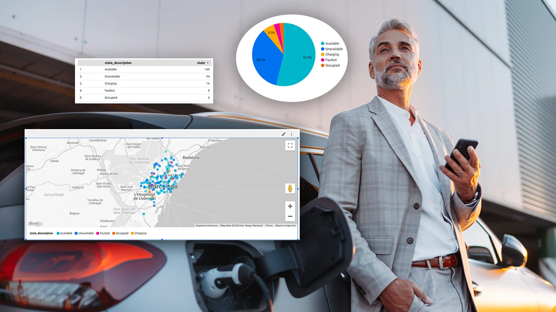
Barcelona
Country: Spain
Open Data Portal: https://opendata-ajuntament.barcelona.cat/
.jpg)
Open Data BCN, a project that was born in 2010, has evolved and is now part of the Barcelona Ciutat Digital strategy, fostering a pluralistic digital economy and developing a new model of urban innovation based on the transformation and digital innovation of the public sector and the implication among companies, administrations, the academic world, organizations, communities and people, with a clear public and citizen leadership.
There is also a relevant approach by Transports Metropolitans de Barcelona which shares an API with real time information related to the public transportation network. An interesting example of such data is the i-Bus service API endpoint, which offers in real time the upcoming transit times of the lines that will pass by a Bus stop, or the electric vehicle charging stations real time status.
It is also possible to aggregate data for the province of Catalunya which can be obtained from the Open data initiative of the Government of Spain. An interesting example is access to real time road incidents data in Cataluña.
👉 Explore our Barcelona interactive demo
Santander
Country: Spain
Open Data Portal: https://datos.santander.es/
.webp)
The Santander Open Data Portal besides access to some interesting datasets, provides a public REST API to allow direct access to the underlying data, including data updated in real time, such as environmental noise and temperature sensors, garbage containers fill level, among others. A really interesting piece of data is the real-time measurements of air quality by sensors aboard public transportation buses, which not only provides the values read by the sensors, but also the location and time the measurement was made.

With the right partners and commitment, you can implement smart city projects that improve the lives of your residents and businesses. Want to learn more? Book a meeting with us today!


.webp)
.webp)
